“Where is Peter Fischer’s Rock?” asked an interested descendant early in my tenure as a Morrison historian of sorts, maybe about 1996. Answering questions was a key part of the job, but this one had me stumped. I’d never even heard of Peter Fischer, though I’m confident Morrison’s earlier historian, Lorene Horton, probably had. His early arrival and many contributions to the area qualify him for “pioneer” status. Why did he seem so little known, hardly remembered?
Peter’s story as adapted and abbreviated from a summary by his great-great-granddaughter Melanie Holmberg:
Peter Fischer, Morrison pioneer
Peter Fischer was born in Germany in 1826 and immigrated to Illinois in 1849 with his family (including parents, brothers, and sister). At age 33, he left the family farm in Illinois (and his wife Catherine) and moved alone to Cherry Creek in the spring of 1859, where he established a nursery business on the shores of Cherry Creek. Catherine joined him in 1860. In 1872 (before the railroad line to Morrison was completed), Peter, Catherine and 6-year-old Clara Fischer moved to Morrison, perhaps because he’d heard about the coming railroad.
After Peter moved to Morrison he “engaged in improving his farm and experimenting on fish and is now in possession of a beautiful beer garden.”1 “Laurelei [also Lorelei] Park, near the mouth of the canon, is the favorite resort of the people of Morrison, and the surrounding country. Its proprietor, Mr. Peter Fischer, has spared neither pains or expense in fitting up a nice place for a summer resort, and seems to be reaping a rich reward for his enterprise.”2
Fischer’s Flume, constructed across Peter Fischer’s Rock “above” Morrison.
Peter may have owned land on “Fischer’s Mountain,” aka Mt. Fischer, now Mt. Falcon. He was also the owner of Fischer’s Ditch and Flume. “Fischer’s Rock,” or “Peter’s Rock,” is the large red sandstone outcrop overlooking Morrison on which he built Fischer’s Flume “to carry water around Mt Glennon to Turkey Creek.”3 He constructed two ponds, one to serve as a swimming pool and bathing area (for which he charged admission) and a lower one to water his livestock and farm (perhaps also for the above-referenced fishery).
After his daughter’s move to Denver and his second wife’s death, Peter suffered multiple financial setbacks and failures. He eventually left Morrison for Denver, impoverished, and was living in a “county home.” He apparently didn’t have a close (or any) relationship with his daughter and grandchildren. At his death, in 1900, he was reported to have dementia.
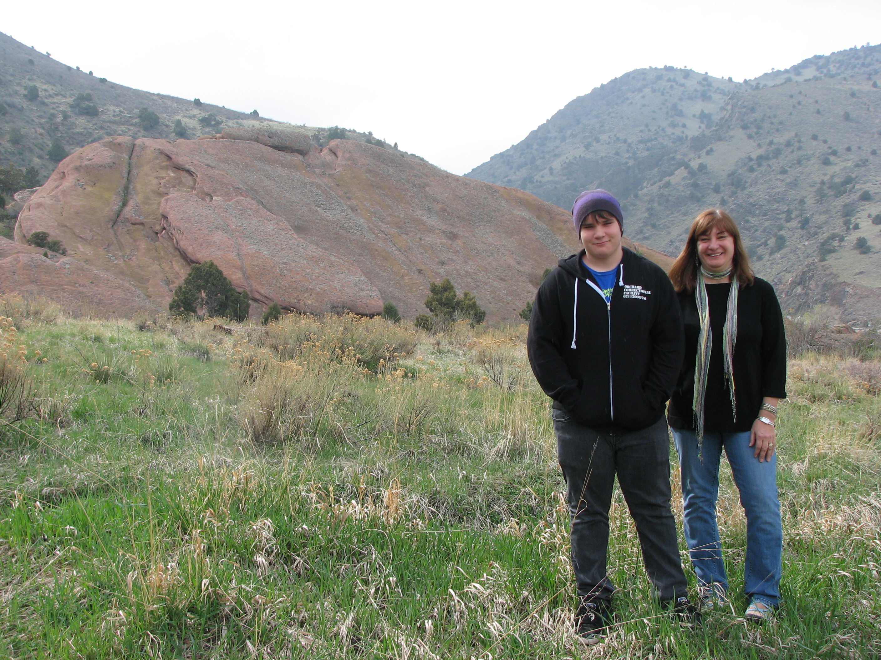
Melanie Holmbergwith son Tim, descendants of the Fischers, on a visit to Fischer’s Rock in 2010.
The story of the Fischer family is, of course, far more complex than this overview. Although Clara was the Fischers’ only surviving child, her marriage to Sabatino Tovani (another story) resulted in six children and an array of descendants.
The flume was short-lived and was therefore sometimes known as “Fischer’s Folly.” Evidence of its presence remains in faint traces on the landscape (see photo below).
Sources:
1 “Morrison Matters: A Word or Two About This Enterprising Foot-Hill Hamlet. Her Business, Agricultural and Grazing Facilities Commented On.” The Rocky Mountain News (Daily), Volume 25, April 27, 1884.
2 “Lively Morrison: A Rough Sunday’s Work—A Man Kicked to Death on Sunday—Notes of Business Progress and Social Gossip.” The Colorado Transcript, July 20, 1881
3 Kowald, Francis. “A Brief Historical Sketch and Some Reminiscences of The Sacred Heart College,” typed manuscript, circa 1935, housed in Archives and Special Collections, Regis University.
Aerial photo of Morrison area labeled showing approximate location of Fischer’s Flume.
Historic structures like these may be lost to “natural causes” like fire and flood, or to deterioration and demolition. Only a handful of Morrison’s buildings date to those early years of the 1870s; many have been replaced. Morrison celebrated its sesquicentennial in 2024, but more change is ahead for this small town. Click any photo to enlarge and view as a slideshow.
#10, Tom Lewis Home, undergoing demolition as of 2025.The Ross Creamery, at the entrance to town. Location now occupied by Conoco Station.#52, Florence Smith Wilson House, 1976. Burned in the 1990s.#26. The railroad station served the town and its visitors until the early 1930s. DPL X-11181.#34. Site of Morrison’s newspapers. Lost to flood?#47. The Swiss Cottage, built by George Morrison in 1874, demolished in 1982. Site is now Bear Creek Nursing Center. This lime kiln stood outside the hogback until the early 1980s. HAER CO-11-5This dance hall, built too near Bear Creek, was lost in the 1938 flood. Its predecessors burned. #39 Horton House Bed and Breakfast, lost to fire in 2015.#25. Mt. Morrison Garage, replaced by a brick building after the 1931 fire.
We are fortunate that, of the 70 documented sites in Morrison’s Historical District, 85% are still intact, though some are modified to various degrees. Seven of the 70 were listed as “sites,” that is, they were already gone in 1976 when the historic district was designated. Only three listed properties (#10 Tom Lewis Home, #39 Abbo’s Dwelling, and #52 Florence Smith House) have been lost since 1976. The Creamery, the Lime Kiln (demolished circa 1985), and the Dance Pavilion were not included in historic district documentation.
From the Morrison Messenger, June 2002 Photos courtesy of Jack Jones
Carl Peinze, real estate agent and former owner of Peinze’s Grocery, continues to build in the new residential subdivision he’s developing in Morrison. Peinze acquired the property and sold several lots during the 1950s, many of which have already had homes built on them. Several other homes are in progress, including a new house at 152 Red Rocks Vista Drive.
Pickup trucks ply the streets, and construction trailers are everywhere, as workers struggle to complete the buildings. The aptly named street, though lacking in trees and other landscaping, affords remarkable views of Morrison’s closest and most celebrated scenic attraction. For the first time in a century, Morrison’s population will swell as the new homes are completed.
View of Red Rocks from Red Rocks Vista Drive, 1962 with houses under construction
In 1976, Lorene (Reenie) Horton and others completed an inventory of town historic buildings and submitted an application for designation of the Morrison Historical District to the National Register of Historic Places. They also published a walking tour brochure and a “Memory Album” booklet that contained photos collected from town residents. We are in the process of updating our “Places” listing with information from that project. Gradually, we’re getting more of Morrison’s historic sites online, some with more current photos.
We’ve kept the original numbering scheme for the town sites, of course, but be aware that some addresses have changed since 1976. In the 1990s, the fire department renumbered many properties, and we’ve not yet cross-referenced them here. This information is presented mostly as it was written in 1976, with a few comments on more current building uses for reference.
As you explore Morrison, keep in mind that, other than the downtown business district, most of these properties are private residences. Click to enlarge the map below.
The Swiss Cottage, built by George Morrison for Governor Evans in 1874, was known by many names through the years.
That’s right, tiny Morrison was once a college town. For just four years, 1884-1888, Morrison was home to “Sacred Heart College,” really more of a prep school as some students were less than 14 years old. Originally founded by Jesuits in Las Vegas, New Mexico, the new Sacred Heart for Colorado opened in a former hotel building with just 24 students.
The building selected was one of Morrison’s dominant structures for nine decades. Known first as the Evergreen Hotel or the “Swiss Cottage,” the three-story building housed the students and their Jesuit instructors. A smaller building on the site provided servants’ quarters. By 1888, the remote location was deemed inconvenient, and the college moved to a new campus at Berkeley, close to Denver, and became Regis College (now University). A close friendship between the Jesuits and John Brisben Walker facilitated the trade, with Walker acquiring title to the Morrison location and renaming it the “Mt. Morrison Casino.” Read more about the Jesuits in Jefferson County here.
Its sandstone bulk loomed over the town’s skyline from 1874 to 1982, when it was demolished after a long and colorful history.
We’ll pick up where we left off, with Town Manager Carol O’Dowd’s account of her meeting with Lee Cox:
We reminisced about his life and how to save his home, now in the new state highway right-of-way. I offered the idea of using his cabin for a town museum. He liked the idea and approved. Lee died soon after he and his relatives gave the necessary signatures; he died comforted by knowing that his log home would live on as Morrison’s natural history museum….
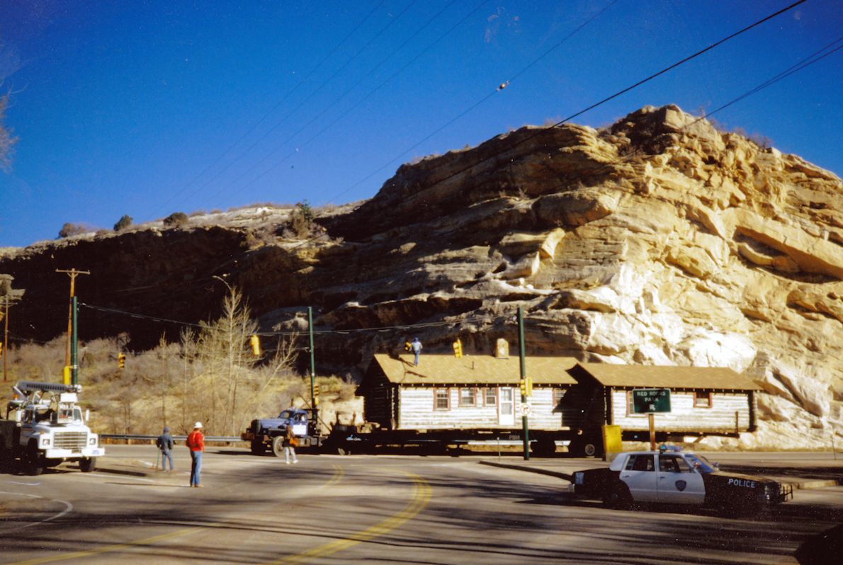
Then came the challenge of moving the cabin. The Highway Department guys had a soft spot for Morrison and maybe for me—I had taken some pretty serious razzing from them in meetings where I was the only woman in a room with 20 engineer-type males. They gave us the cabin and 10 days to move it before the bulldozers arrived. Robin Smith helped me find a house-moving company just in time.”
Meanwhile, retired USGS paleobotanist and Town Board member Dick Scott had convinced the Town Board that a natural history museum, especially a free building complete with himself as free paleontologist-director, would be a great asset for Morrison. He writes:
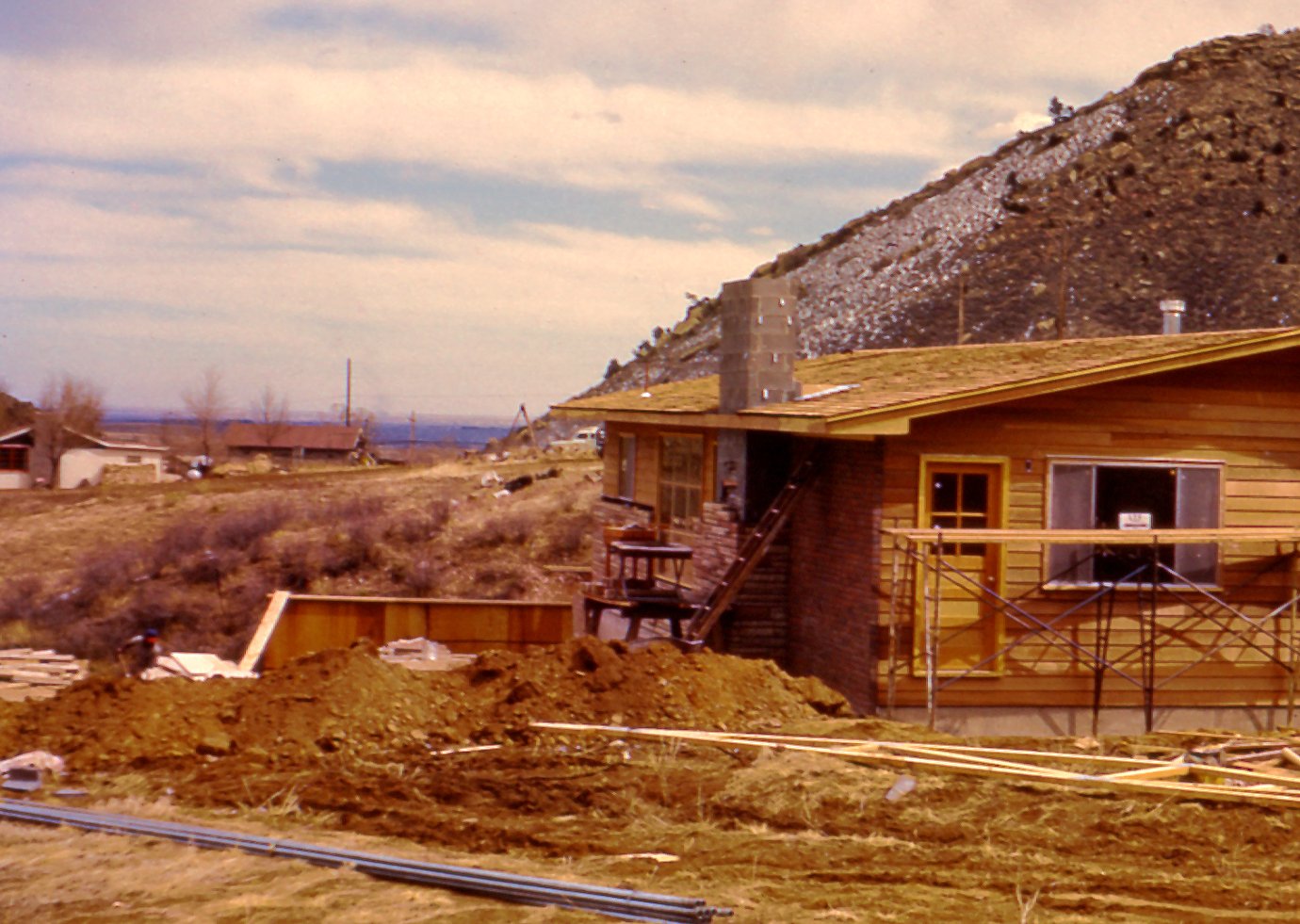
“We picked out a site on Morrison’s 80-acre Designated Open Space at the south edge of town. The spot was next to the highway and on a hillside where a basement would double our space. Jack-of-all trades DeWayne Rhodig fired up the town backhoe.
The moving company slid long steel beams and wheels under the cabin. Early one Saturday morning a bulky procession led by our lone police car crawled down Morrison’s main street, lumbered around the left turn southward across Bear Creek, and inched its way into position above DeWayne’s excavation. Later, DeWayne constructed basement walls underneath. Lee Cox’s cabin then became the Morrison Natural History Museum…”
Cox Cabin on the move through Morrison in December 1987.
More from Dick Scott’s notes on Morrison’s late 20th-century history:
A few pages back we left the Cox cabin perched on steel beams over a hole in the hillside, awaiting conversion to be the Morrison Museum. Why start a museum? I had multiple reasons to believe in the project. First, Morrison’s unique role in the history of paleontology certainly justified a museum. Second, the museum’s visitors could bring needed dollars to our restaurants and shops. Third, the museum as an informal teaching tool could broaden children’s interest in science and nature through their strong fascination with dinosaurs. It was worth a try.
Arthur Lakes’s discovery of dinosaur bones north of Morrison in 1877 earned the small town a significant spot in history. Before the Morrison Museum formally opened, interest was arising in another kind of dinosaur fossils. When Alameda Parkway was extended over the Dakota hogback in 1937 by WPA workers, dinosaur tracks were uncovered along its route.
The east-side road cut through the steeply dipping Dakota sandstones, exposing large surfaces bearing ripple marks and literally hundreds of dinosaur tracks… Then reports surfaced about people digging up the tracks and stealing them. As the Morrison Museum began to take shape, Denver’s Metropolitan State University professor Dr. Martin Lockley, a dinosaur track expert, expressed concern about theft and destruction of these tracks. His concern led to the forming of the Friends of Dinosaur Ridge. The origins of the Morrison museum and the Friends were intertwined.
The early history of the Morrison Natural History Museum is tied to that of the Friends of Dinosaur Ridge, who aimed to protect the dinosaur tracks and educate the public about them. Dick Scott served as the first director of both entities, and the Friends initially met at the unfinished museum, which remained their headquarters until about 1993.
Cox Cabin on the move through Morrison in December 1987.
Cox Cabin arrives at a newly excavated site south of Morrison.
With its foundation/basement completed, the building awaits final transformation.
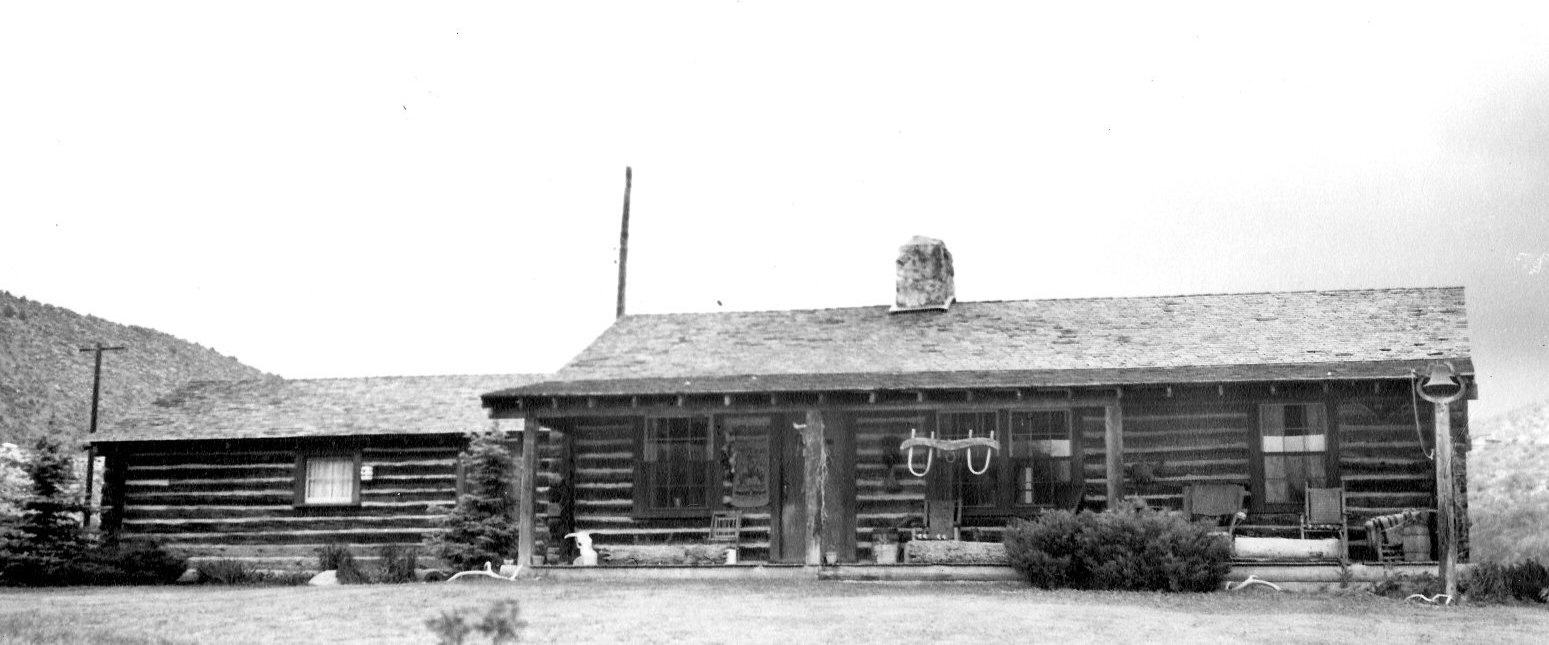
In its original setting, this cabin nestled into a rocky hillside north of Bear Creek was built here by Lee Cox in the 1940s. The one-story building was designed after a stagecoach stop from settlement days, giving it a vintage look earlier than its origins. Mr. Cox probably also gave the adjacent hill its name, Bead Hill, for the Native American artifacts he collected in the area and elsewhere. It is not, to our knowledge, an official placename.
Lee Cox, relaxing on his porch in happier days.
Mr. Cox continued to raise cattle on this land, once owned by the Rooney family, until the 1980s, when the site was endangered by the advent of the beltway being constructed around Denver. His later years were reportedly spent in frustration and bitterness, and he died about 1987 in a nursing home in Morrison. Former Town Board member Dick Scott reconstructs the story:
When the Town hired Carol O’Dowd [as Town Manager] in 1985, the state had already begun obtaining right-of-way for the new four-lane beltway, C-470, around the metro area. The Morrison interchange plan crossed Lee Cox’s ranch and, unable to sell it to be moved, the state would soon demolish his large, modern (built in 1945) “log cabin” ranch house. Lee alone, heartbroken, ill at eighty-some, dourly resisted each visitor while holding his shotgun when answering each knock at his door. Carol described her visit with Lee to me:
“Visiting all Morrison’s neighbors, I knocked on Lee Cox’s door. My smile got me past his shotgun, and I built a relationship of trust. Ill health soon sent him to the Morrison Nursing Home and I visited him there. We reminisced about his life and how to save his home, now in the new state highway right-of-way….”
A last-minute effort saved the cabin itself (read Part 2 here), but the site, now a stone’s throw from C-470, is currently occupied by the Town of Morrison’s sewage treatment plant.
Lee Cox’s champion entry in the 1948 National Western Stock Show.
More information on Morrison history is available at Jeffco Archives. Contact Archivist Ronda Frazier (rfrazier@jeffco.us) for access to the Morrison History Collection.